


Travel
A Trip from Springfield to Arizona
If you can’t decide between a mountain town and desert terrain for your next outdoor adventure, why not choose both in Arizona? It’s easy to get there from Springfield.
by Sony Hocklander
Jan 01 2024 at 8 a.m.
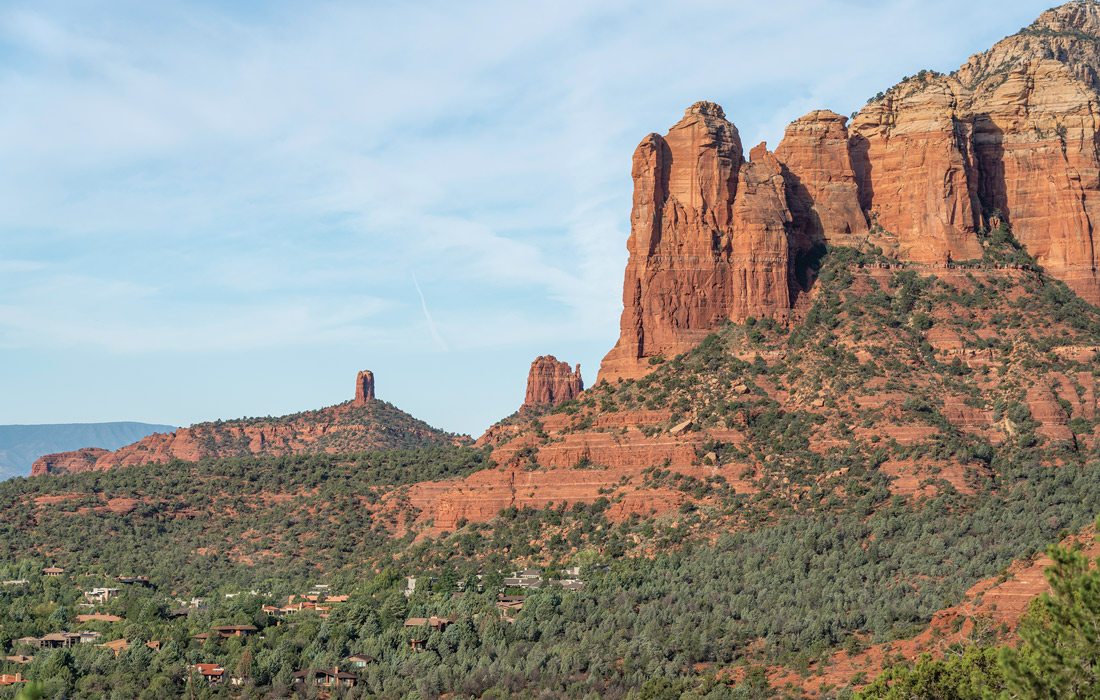
Photo courtesy Sony Hocklander
Waking up in Arizona not long ago, my husband and I sipped our first cup of coffee while marveling with good friends at our backyard view. Red rock formations soared against a deep blue sky as the sun rose just beyond our vacation house in Sedona. It was breathtaking and had us giddy to get onto a nearby trail.
That was Day One of an action-packed fly-and-drive road trip to Sedona and Flagstaff in less than a week, made possible by a direct flight on Allegiant Air from Springfield to Mesa, Arizona. We hiked, dined, raised a few mugs, rode jeeps and left with photos and good memories of amazing red rocks, peaceful Aspen groves and historic places. There’s so much to see and do, we’re ready to go back for more.
Feel inspired? Plan now for your own spring or fall adventure with a few tips from ours.
Photo by Sony HocklanderThe Broken Arrow Pink Jeeps Tour took guests past this stunning desert vista.
Serene Sedona, Arizona
Whether you go for a spiritual experience, to hike and explore—or both!—Sedona in the heart of Red Rock Country is unlike any place else. Stay in town for easy access to shops, dining and spa or wellness experiences, or book a rental on the outskirts (as we did) where you can practically walk or bike to one of more than 200 trailheads.
Hiking and Off-Roading
Our first morning, we parked at the Brins Mesa/Jim Thompson Trailhead for a hike in the Red Rock Secret Canyon Wilderness Area of the Coconino National Forest. We started along the Cibola Pass Trail, eventually reaching Devil’s Kitchen—an impressive sinkhole—to pick up Soldier Pass Trail leading to the Seven Sacred Pools (seven depressions that retain water). For a roughly 3-mile hike, return from here to your car. We continued for a 6-mile loop, taking Soldier Pass up a steep climb to a gorgeous red-rock-view plateau. Connecting to the Brins Mesa trail, we descended with views of Mormon Canyon.
After lunch, it was Pink Jeep time! We’d booked an off-road tour months earlier with Pink Adventure Tours. The two-hour Broken Arrow adventure climbed to Chicken Point with incredible views and to the massive Submarine Rock as the driver shared tidbits of local history and geology. The bouncy adventure ended with some serious rock-crawling down rugged slopes and steps.
Embrace the Vortex
Sedona is known for what is said to be a mysterious natural and sacred force—or energy—emanating from the land and rocks. A place where the force is particularly strong, called a vortex, is supposed to help with healing and self-exploration. There are even vortex tours. Four well-known locations include the Airport Mesa, Cathedral Rock, Bell Rock and Boynton Canyon—all of which have hiking trails.
We timed our visit to Airport Mesa at dusk because it’s also known for incredible sunsets. I’m not sure if we felt the vortex here or anywhere else, but Sedona certainly inspires awe.
Dining and Shopping
To dine at the most popular Mexican restaurant, Elote Café, word is you need to make reservations weeks ahead. For the best brunch, try Red Rock Café. But there are dozens of dining options. You can’t go wrong with Hideaway House, a charming indoor/outdoor café built on the edge of a deep canyon with three patio levels and a gorgeous view. Get the house-made bread with your choice of salads, soups, specialty pizzas, sandwiches and dinner options. If you enjoy craft beer, they have local brews on tap.
Downtown Sedona has all kinds of boutiques and art galleries, too. At the one-stop Tlaquepaque Arts & Shopping Village you’ll find original art, clothing, accessories, jewelry and more; plus, there’s dining, drinks and music.
High Adventure
Early in the morning on Day Two, we packed up the car, checked out and headed for Devil’s Bridge, one of Sedona’s most photographed and popular adventures. It’s absolutely worth the 400-foot climb to walk out on the 54-foot-high, 45-foot-long sandstone natural arch bridge. (Tip: Go early! Trailhead parking fills fast and you may have to wait for your bridge-walk photo.)
We parked at the Dry Creek Trailhead and took the scenic Chuck Wagon Trail, weaving through groves of cacti, yucca and juniper trees, with an unexpected bonus of witnessing hot-air balloons rise from the low-growth forest floor. Connecting to the Devil’s Bridge Trail, the path ascends steep rocky steps to an overlook where hikers walk onto the natural arch. Most have a friend, or maybe a stranger, take their picture. From the viewing area, the top of the bridge looks narrow. But like Hawksbill Crag in Arkansas, it’s wide enough to avoid the edge. We returned to our car via a shortcut along Dry Creek Road and headed toward Flagstaff.
Red Rock State Park
Hike, mountain bike and ride horses in the park about 20 minutes southwest of Sedona. Or simply enjoy the views along the 7.5-mile Red Rock Scenic Byway.
Chapel of the Holy Cross
Built in 1956 atop a 1,000-foot rock wall, this must-see chapel has an amazing view.
Slide Rock State Park
Shades of Johnson’s Shut-ins, cool off here in a natural 80-foot-long rocky water slide.
Oak Creek Canyon Scenic Drive
The drive between Sedona and Flagstaff is only 45 minutes. But take your time along the gorgeous Oak Creek Canyon Scenic Drive. The Midgley Bridge Observation Site has a great view, and the Oak Creek Visitor Center has maps and information. Near the Visitor Center, we had lunch in the shaded ambiance of Indian Gardens Café and Market, a garden patio eatery with a casual menu (plus coffee, beer and wine).
The scenic switchback drive passes trailheads, overlooks and recreation opportunities including Slide Rock State Park and Oak Creek Canyon Natural Area. The most popular hike is the West Fork Trail at the Call of the Canyon day use area.
If you only have time for one short stop, choose Oak Creek Vista. The photogenic day use area near Flagstaff has tall evergreens and incredible views. The short walk around the overlook doesn’t take long, and you can shop for original jewelry and crafts by Native Americans who set up daily booths.
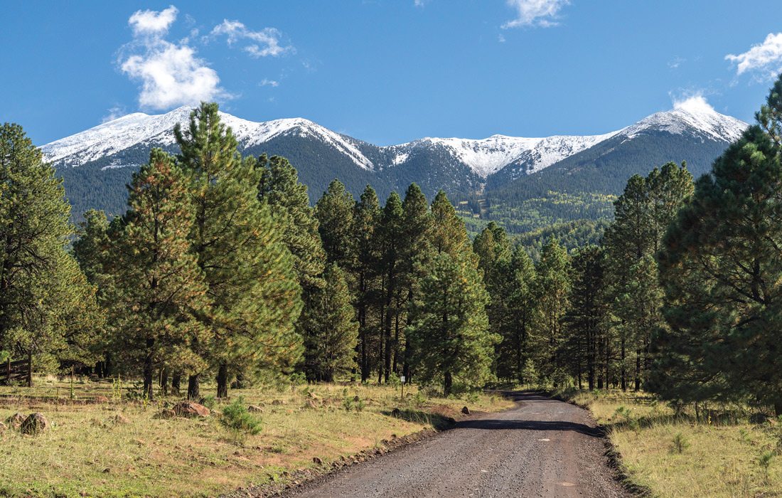
Photo by Sony HocklanderThe Flagstaff Scenic Drive is a great option for viewing the area from the comfort of your car.
Friendly Flagstaff, Arizona
In Flagstaff, hotels and rentals are plenty, whether you stay near downtown (as we did) or around the outskirts. When planning your own trip, consider some of these adventures.
Historic Downtown and Railroad District
Flagstaff exudes a mountain town vibe, and its downtown begs to be explored. This bike- and pedestrian-friendly section of town along Route 66 features turn-of-the-20th- century buildings, hotels, quaint boutiques, art galleries, restaurants, watering holes, historic landmarks and lots of festive events. Our first afternoon, we stopped by the Flagstaff Visitor Center in the Historic Train Station for information and maps. We enjoyed sipping brews on the patio at Lumberyard Brewing Co., a craft brewery taproom and grill housed in an old Flagstaff lumber-era building. And we spent a festive evening our second night near Wheeler Park at Dark Sky Brewing Company for an outdoor dining and cocktail experience.
Trails and Mountains
Like Sedona, many trails are easy to access from the outskirts of town. We started our first full day with a hike on the Elden Lookout Trail and Fatman’s Loop in north Flagstaff, a desert-meets-mountain slope with petrified lava in a pinyon-juniper woodland and great views of Flagstaff.
An easy place to hike—or stroll or ride a bike—is Buffalo Park in north Flagstaff. The expansive natural outdoor space is part of the Flagstaff Urban Trail System (FUTS), the Arizona Trail and the Coconino National Forest. For a short scenic walk, take the main 2.2-mile loop. You might still see snowcapped peaks!
On our second day, we drove up to the Arizona Snowbowl, a winter ski resort in the San Francisco Peaks with hiking trails when the snow melts. The gorgeous, easy 2.5-mile Aspen Loop Trail meanders through glades of wildflowers and grasses into woods full of tall aspen, spruce and pine trees. You can also take a Scenic Gondola Ride, play disc golf, dine out and more.
One of our favorite adventures, roughly 10 miles southeast of Flagstaff, was at Walnut Canyon National Monument. The 400-foot-deep Walnut Canyon features well-preserved 12th- and 13th-century dwellings carved into limestone bluffs by the ancient Sinagua people.
The easy 0.7-mile Rim Trail leads to a partially rebuilt pueblo and pit house. The 1-mile Island Trail descends into the canyon, providing up-close views of awe-inspiring dwellings carved into the rock. It’s hard to imagine how the Sinagua people accomplished such a feat. The trail loops back, ascending 273 steps to the top. This national site requires a fee or pass. Our group returned to stay in Mesa the fifth night to catch an early flight home the next morning. Good memories of our southwest adventure still linger.
We saved a few great options for our next trip, including:
Lowell Observatory
This is where Pluto was discovered.
The Arboretum at Flagstaff
Immerse yourself in a ponderosa forest surrounded by the San Francisco Mountains.
Museum of Northern Arizona
Learn more about the natural and cultural heritage of northern Arizona.
Wupatki National Monument
Discover early pueblo life of 1100s ancestors of the Hopi people, and the nearby Sunset Crater Volcano.
Plan Your Trip
It’s not the fanciest—or roomiest—airline we’ve flown, but you can’t beat the price and traveling direct on Allegiant Airlines to the Phoenix-Mesa Gateway Airport, which is about the size of Springfield’s airport and is located in a suburb of Phoenix.
Check outgoing and incoming flight times and days, which are limited depending when you go. Our group flew out on a Tuesday and returned the following Sunday. You can also extend your trip to seven nights.
For the five-night trip, book rentals for two nights in Sedona and two nights in Flagstaff, then a hotel in Mesa close to the airport if your flight home the next day is early. Rent a car to pick up and return at the airport.
Drive Times
Mesa to Sedona: 2 hours, 25 minutes
Sedona to Flagstaff: 45 minutes
Flagstaff to Mesa: 2 hours, 45 minutes
Hiking Tips
• Arrive early! The most popular trailhead parking lots fill up fast. In Sedona, consider using the free shuttle system to reach trails on high-traffic days.
• Bring a hat, sunscreen, proper hiking shoes, salty snacks and more water than you think you need.
• Keep a map handy (on paper or your phone) since many trails connect and cross.
• Buy a Sedona Red Rock Pass if you hike several trails on National Forest land where fees are $5 a day or $15 for seven days. Purchase a pass at Sedona’s Visitor Center, local businesses or online. America the Beautiful passes also work. Note: Some recreation areas and state parks charge a separate admission fee.
Extend Your Trip
While our friends flew home after five nights, we extended our trip to seven nights with a side trip to Page, Arizona and the Glen Canyon National Recreation Area. Page is a great home base for visiting:
Horseshoe Bend
The well-recognized Glen Canyon bend in the Colorado River draws thousands of visitors. Pay $5–$10 to park and walk a 1.5-mile paved out and back trail to see this natural wonder.
Lake Powell Dam
View the dam from the Glen Canyon Dam Overlook, a short 0.2-mile descending trail in Page. Visit the Carl Hayden Visitor Center at the dam (nps.org or lake-powell-country.com) to learn about its history and walk the pedestrian dam bridge.
Lake Powell/Colorado River
There are dozens of ways to enjoy Lake Powell, which at 186 miles end to end looks more like a wide river with steep canyon walls than a lake. You can also book a Colorado River raft float tour from the dam through Horseshoe Bend to Lee’s Ferry and Marble Canyon.
Antelope Canyon
Owned and managed by the Navajo Nation, this slot canyon, on many photographers’ bucket lists, can only be visited with an approved tour company.
Toadstool Hoodoos Trail
One of our favorite adventures 30 minutes into Utah, this easy trail features balanced rock formations that look like giant toadstool mushrooms.
Navajo Bridge / Lee’s Ferry
About 45 minutes from Page, the historic Navajo Bridge crosses Marble Canyon and the Colorado River. Lee’s Ferry, 15 minutes farther (nps.gov), was the only way for travelers to cross the river and canyon in the late 1800s. Today it’s a historic recreation area with old ruins and several great trails.