


Travel
A Trip to the Smoky Mountains
The two-state Great Smoky Mountains National Park makes an easy road trip vacation from Springfield. If you go, consider staying on the North Carolina side for a less touristy experience.
Sony Hocklander
Mar 2024
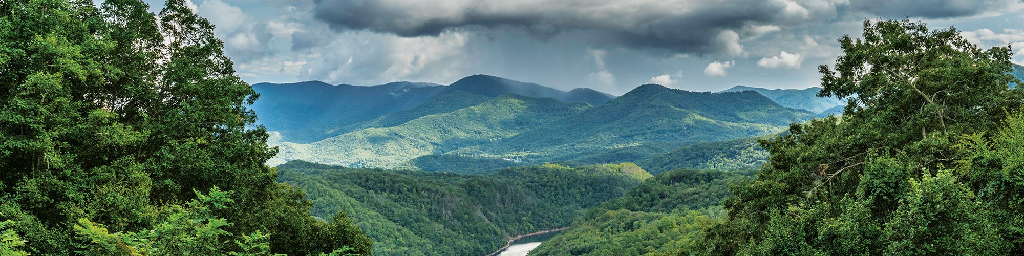
Photo by Sony Hocklander
Living in Springfield means we have easy access to outdoor adventures less than three hours away. But we’re just as fortunate to live within reach of adventure-rich vacation destinations you can drive to in a day.
Count the Great Smoky Mountains National Park among them. If you long for soaring peaks, amazing vistas, tall waterfalls, rivers to raft, incredible hikes and historic culture, put the Smokies on the top of your go-to list.
Covering half a million acres and straddling two states—Tennessee and the western tip of North Carolina—there’s more to see and do inside and around the park than you could get to in a single week. But you’ll have a blast trying.
While Ozarkers tend to book lodging on the Tennessee side, we visited North Carolina’s southern side near Bryson City, about 90 minutes farther, for a less touristy experience.
Why Bryson City and Swain County
If you’d rather save Branson-style entertainment for, well, Branson, pass on tourist towns near the park in Tennessee and go south. After all, about 40 percent of the Smoky Mountains is in North Carolina’s Swain County, considered the quieter, less crowded side but rich with mountain adventures in and around the national park.
We stayed near Bryson City, a quaint small mountain town of 1,500 just south of national park boundaries. It makes a great central location for searching nearby rentals, and once you arrive, it’s a charming home base for picking up groceries, dining out, enjoying craft breweries and wineries and visiting quaint shops.
Bryson City is also a Smoky Mountains gateway town to enter the park at the Deep Creek Recreation Area. Nearby, explore the Nantahala River Gorge, experience Cherokee and Appalachian culture, view breathtaking vistas, hike to gorgeous waterfalls and drive scenic byways.
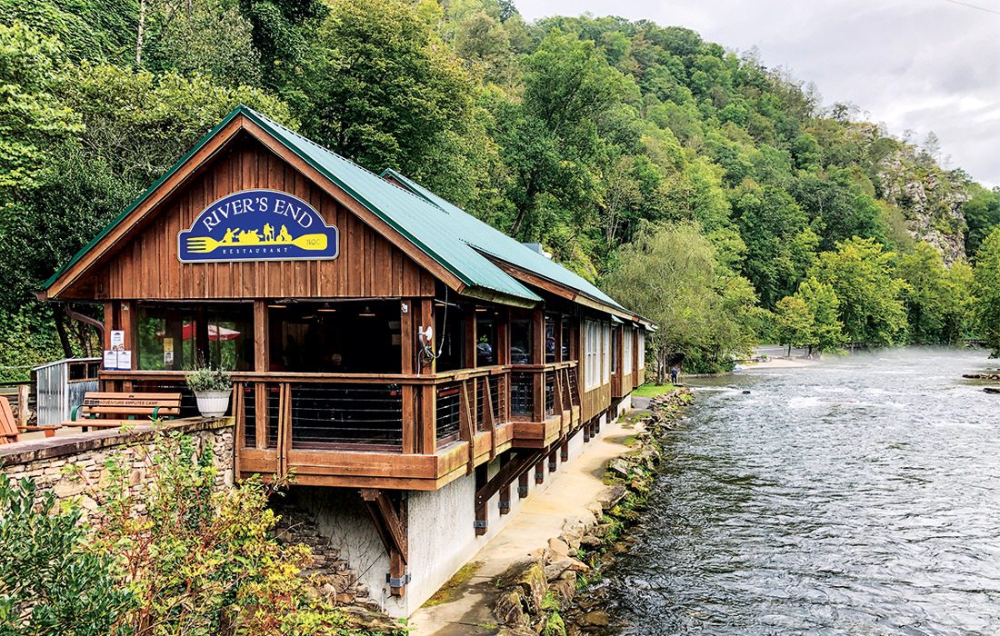
Photo by Sony HocklanderRiver's End Restaurant in Bryson City sits beside the Nantahala River.
The Smoky Mountains’ Southern Border
Bryson City is a convenient place to start your first day out. Stop by the 1908 historic courthouse, now a visitor center and heritage museum, where staff can help you plan. Also find maps, brochures and information to take along.
On our first day, we entered the Smokies via the Deep Creek Recreation Area, just north of Bryson City. It was a lovely introduction to the national park with easy hiking trails and three beautiful waterfalls, plus places to fish, camp and picnic. We also enjoyed watching a popular activity: tubing down Deep Creek (on our “next trip” list). Hike a short loop trail to see the Juney Whank Falls, then hike the Deep Creek Trail to Toms Branch Falls and Indian Creek Falls. There is plenty to see and photograph.
Not far from Deep Creek is the “Road to Nowhere,” as locals call it. Officially, it’s the scenic Lakeview Drive, which goes six miles into the park and ends somewhat abruptly at the opening of a tunnel. The short scenic drive provides views of Fontana Lake and access to several trails including the Noland Creek Trail (a good place to fish). Like other tourists, we parked and walked through the quarter-mile tunnel, which was good timing since it started to rain. The tunnel area also connects to the Goldmine Loop, Forney Creek Trail, Lakeshore Trail and more.
Adventures Start in Cherokee
The main North Carolina Smoky Mountains gateway is the reservation town of Cherokee. Stop at the Oconaluftee Visitor Center to gather maps, information, ranger advice and, if you don’t have one yet, a parking pass ($5, $15 or $40) for stopping in the park. You might even see elk grazing in fields nearby.
Explore a bit of Cherokee before entering the park, or plan to return another day. A few spots of interest include the Museum of the Cherokee People, the Oconaluftee Indian Village, Harrah’s Cherokee Casino Resort, shopping, fountains in the summer, the Oconaluftee Islands Park and painted bear sculptures. Stop at the Cherokee Visitor Center for information.
Don’t miss the Smoky Mountain Farm Museum near the Oconaluftee Visitor Center. The late 19th century farm was recreated by the National Park Service using authentic structures from around the park. Walk the easy Oconaluftee River Trail and, if it’s open, visit the Mingus Mill.
Less than 15 minutes from town at the Mingo Falls Campground is one of the southern mountain area’s tallest waterfalls at 120 feet. The trail, less than half a mile, is mostly up a long set of stairs. It’s worth the uphill climb to see and photograph these spectacular falls.
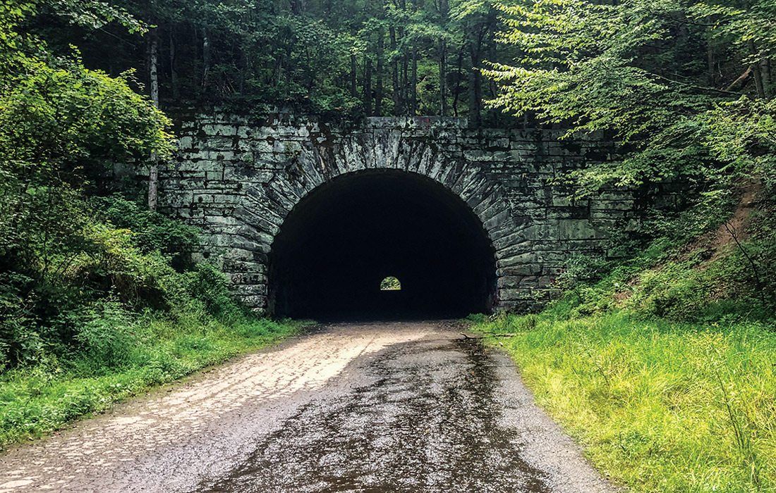
Photo by Sony HocklanderThe tunnel on the Road to Nowhere is a unique sight to behold.
Newfound Gap Road
Our longest day in the Smokies centered around Newfound Gap Road (a.k.a. US-441). Some of the most scenic areas of the park can be accessed from the 31-mile south-north artery that connects the two states between Oconaluftee and Sugarlands visitor centers.
Plan your priorities before getting too far, you could stop dozens of times and hike a variety of trails. The southern end of the road passes on Fighting Creek Gap Road about four miles to reach Laurel Falls. The paved 2.4-mile out-and-back trail attracts families with kids who love to splash.
During our return trip south, we made a few more scenic stops including the Morton Overlook for its panoramic views (also known for great sunsets). Just past Newfound Gap, we turned west for seven miles to Clingmans Dome, an observation tower and the highest point in Tennessee at 6,643 feet. We hoped the fog would clear by time we arrived but alas, it did not. We still huffed our way up a steep half-mile trail to reach the 45-foot tower with a 360-degree view. Once in the dome, the clouds broke long enough for a taste of the amazing view.
How to Get to the Great Smoky Mountains National Park from Springfield
Take U.S. 60 east out of Springfield to Poplar Bluff and from there, choose from one of two directions that take roughly the same amount of drive time.
The first (683 miles) goes through Nashville to Bryson City. This itinerary includes 11 scenic miles in North Carolina of what’s known as the Tail of the Dragon (a favorite for motorcyclists).
The second (715 miles) goes through Chattanooga, entering North Carolina farther south. Choose this direction to stop at additional scenic recreation areas including the Ocoee River in Tennessee, known for its whitewater rafting.
Blue Ridge Parkway and Pisgah National Forest
The next day we drove back to Cherokee for another day’s adventure, this time starting a portion of the famous 469-mile Blue Ridge Parkway. We enjoyed several overlooks on the BRP including Lickstone Ridge, Thunder Struck Ridge, Woolyback, Cranberry Ridge, Thomas Divide and the Waterrock Knob Visitor Center at 6,000 feet elevation.
While there were many more sites on the BRP, we jumped off near Waynesville to chase waterfalls in the Pisgah National Forest area, starting with the Moore Cove Falls Trail off U.S. 276. The waterfall, somewhat remote, is easy to find at the end of a .7-mile trail that crosses Looking Glass Creek. There’s a viewing platform some distance from the falls but we saw other hikers splashing at the base.
Continuing east on U.S. 276, we came to the crowd-favorite 60-foot Looking Glass Falls. Trailheads for hikes to Looking Glass Rock and John Rock are three miles away, and the popular Sliding Rock recreation area—a natural waterslide experience—is just two miles away.
About the Great Smoky Mountains National Park
With its diversity of terrain and points of interest within half a million acres, the Great Smoky Mountains is the most visited national park in the United States, according to the National Park Service. Evenly divided between Tennessee and North Carolina, the park preserves historic spots within the ancient Appalachian Mountains including those built between 1933 and 1942 by roughly 4,000 Civilian Conservation Corps workers.
Considered the most biodiverse park in the national park system, it features old growth forests, spring wildflowers and many animals including elk, black bears, white-tailed deer, box turtles, spotted salamanders, barred owls and coyotes. It’s also a cultural adventure: Expect to experience a taste of Southern Appalachian history. Plan also for temperature variations up to 20 degrees, depending on elevation.
Families can access ranger-led programs for children during spring, summer and fall. And kids between ages 5 and 12 can become junior rangers. Plus the Great Smoky Mountains Institute at Tremont offers summer camps, programs, family camps, workshops for kids and more. The Smoky Mountain Field School has weekend workshops and activities for families.
Fast Facts
Entry Fee: None
Parking Passes: Required to stop more than 15 minutes. Purchase online or at visitor centers for $5 (daily), $15 (weekly) and $40 (annual). Find out more from the National Parks Service.
Elevations: 875 to 6,643 feet
Main Artery Road: Newfound Gap Road, north to south
Miles of Roads: 384
Miles of Streams: 2,900
Black Bears: Roughly 1,900
Most Popular Trails: Charlies Bunion, Alum Cave Bluffs, Andrews Bald, Rainbow Falls, Chimney Tops. Learn more from the National Parks service.
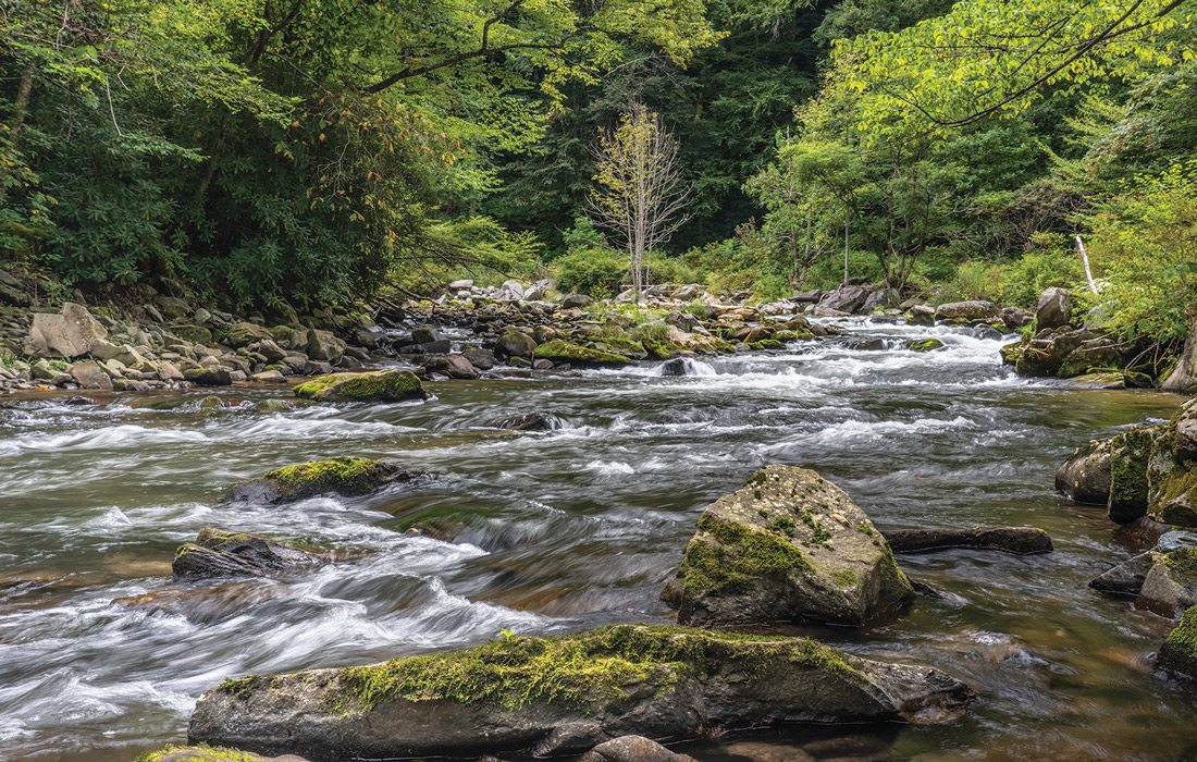
Photo by Sony HocklanderNantahala means “land of the noon-day sun” in the Cherokee language.
Nantahala River Gorge
We saved river-centric adventures around the Nantahala Gorge for our last day of vacation. Nantahala means “land of the noon-day sun” in the Cherokee language. It makes sense: The river flows through an eight-mile gorge so deep, some places only get sunlight for a short time each day.
The river, with water levels controlled by a dam, is central to the region’s outdoor scene, especially whitewater adventures via several outfitters. A scenic drive west of Bryson City along U.S. 19/74 goes through the gorge where zip lines, places to dine and stay and more river recreation, including trout fishing, are available.
While exploring the Nantahala, we stopped now and then to fish and take photographs. We also walked part of the two-mile Nantahala River bikeway near the upper cascades and stopped at the Nantahala Outdoor Center where, in addition to river views and adventures, visitors can also dine at riverside restaurants.
Exploring Wayah Road is a great way to see the river up close at handicap accessible fishing piers and pools near cascading falls. The river and its tributaries, including White Oak Creek, are simply gorgeous. With so many pretty cascades to explore, we could have wandered all day. And the next. And the next.
With all that we saw, there’s so much more to see: It’s a sure bet we’ll go back.
Where to Stay When You Visit the Great Smoky Mountains National Park
The national park has 10 developed campgrounds including several in the southern regions, plus more than 100 backcountry sites. More campgrounds are available outside park boundaries in surrounding communities including 10 with Bryson City addresses.
Not a camper? Some campgrounds also have cabins and yurts, and there’s a plethora of cabins, rentals and hotels south of the park. In addition to searching VRBO and Airbnb for rentals, check out the list of 15 lodge and cabin companies on the Bryson City website as we did.
Note there are no cabins or lodges within the national park except one you must hike to reach. LeConte Lodge, open March 25–November 27 in 2024 with dining and a capacity of 60, is accessible via five different trails ranging five to nine miles each. Make your reservation well ahead of time.